|
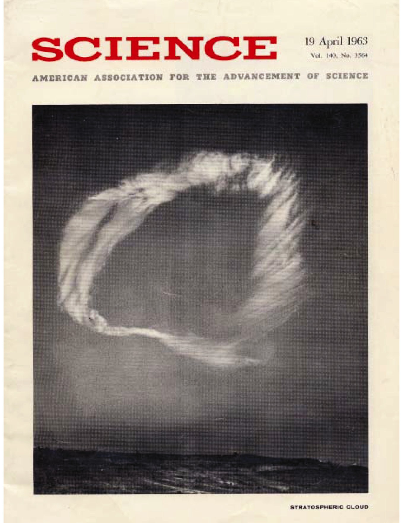
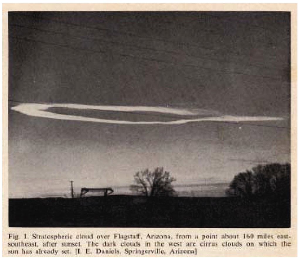
Science Magazine 19 April 1963 Vol. 140 No. 3564 Ring-shaped cloud seen at sunset on 28 February 1963 in northern Arizona and areas of nearby states. The height, as estimated from four photographs made in Tucson, Arizona, about 190 miles to the south of the cloud (which appeared overhead near Flagstaff), is about 35 kilometers. This photo was taken by Clarence E. Peterson of Bremerton, Washington, while he was looking almost due north from near Camp Verde, Arizona. The unusual nature of the cloud was evident to observers who noted its striking luminosity long after the sun had set at ground level. It was at least 11 kilometers higher than the upper limit of possible jet contrail formation, and was at least 5 kilometers higher than previously reported nacreous clouds of the arctic type. Its true nature is still unknown; more photos are being sought for triangulation purposes. See page 292. Stratospheric Cloud over Northern Arizona Abstract. Near sunset, on 28 February 1963, a cloud of unusual configuration and coloration was observed in widely scattered localities in Arizona and some surrounding states. The cloud took the form of a large oval ring (clear in the middle) with the long axis running north and south (Fig. 1 and cover photograph, this issue). It remained brightly illuminated well after the sun had set on high cirrus clouds to the west. From Tucson, 190 miles to the south, its angular elevation appeared to be about 6 degrees. A rough computation of its height, based on sunset geometry, (1) made immediately after the cloud entered the earths shadow, led me to appeal by press and radio for confirmatory reports in order to establish the approximate location and to secure descriptions from the largest possible number of other observers. From approximately 150 reports, many communicated by persons well aware that they had seen a type of cloud unprecedented in years of skywatching, it was quickly established that the cloud lay overhead in the vicinity of Flagstaff, Arizona, that it exhibited iridescence of the sort associated with stratospheric nacreous clouds in the arctic (2,3), and that its internal structure was very peculiar. To observers nearly underneath, the colors green and blue were visible, and a pinkish cast was noted at times. A fibrous texture, described by several independent observers as resembling a wood grain appearance, was present over much of its northern extent, but its southern end was denser and more cumuliform. Its overall shape was compared by some (ranchers) to a horseshoe or a horsecollar if it was viewed from south; from the north it appeared as a closed loop with a long thin trail that could be seen extending northward, from the oval, and several observers in that sector compared its shape with that of a hangmans noose. The cloud was seen from distances as great as 280 miles (near Douglas, Arizona and Albuquerque, New Mexico, respectively).
Many observers reported a second cloud off to the northwest of the main cloud, with shape very much like that of the main cloud, but only about a quarter as large. Correctness of these reports has been established from some of the first photographs that have come in from northern Arizona. The cloud was evidently moving generally south-eastward, though visual reports are in some conflict on this point; this point can only be resolved from further studies by triangulation. By fortunate coincidence, the cloud appeared within a few tens of miles of the U.S. Weather Bureau radiosonde station at Winslow, Arizona, and a high-altitude sounding had been completed there only an hour before the appearance of the cloud. A jet stream lay almost directly under the cloud and over Flagstaff, and there were peak winds of 98 knots from the northwest occurring over Winslow at an altitude of about 11 kilometers. The radiosonde run terminated at the 13-millibar level of atmospheric pressure (about 29 km), where the temperature was -46 degrees C. There was very little direction shear in the Winslow wind sounding, a condition known to favor formation of mountain waves and believed to be conducive to nacreous clouds, at least in Scandinavia (2). It is possible, therefore, that the San Francisco Peaks just north of Flagstaff disturbed the flow so that wave motion was set up in the stratosphere, but this remains a conjecture, pending further study of reports of first appearance. Whereas some recent studies (4) suggest strong local stratospheric cooling as a prerequisite for the formation of nacreous clouds, the sounding at Winslow showed little departure from average temperature conditions in the lower and middle stratosphere. Photogrammetric analysis of the four photographs known to have been taken in the Tucson area have yielded elevation angles of the near point ranging from 5.9 to 6.2 degrees. Because the exact range to the nearest point of the cloud is not yet known to better than 10 or 15 miles in 190 miles, the exact height cannot yet be determined. However, the cited elevation angles plus allowance for earth curvature give a cloud height of 35 kilometers, possibly a bit higher if the range to the near point proves to be greater than 190 miles. This height is distinctly greater than that of reported Scandinavian nacreous clouds. Photogrammetric heights obtained over many years by Stormer and others (2,3) are no higher than 30 kilometers, and the majority lie between 22 and 28 kilometers. The estimated height of 35 kilometers rules out the possibility that the Flagstaff cloud could have been the condensation trail from a jet plane. The present American altitude record, made under the most favorable conditions directly above the home field by a Lockheed F-104 in 1959, is 103,395 feet (31.6 kilometers). Perhaps more conclusive is the fact that the upper limit of height for possible contrail formation (5) as indicated by the sounding from Winslow was just under 24 kilometers at the time of the clouds appearance. These preliminary indications mark the Flagstaff cloud of 28 February as a most unusual phenomenon of considerable meteorological interest. Requests for photographs, still being made at time of this writing, have already brought promises of photographs from a total of 16 sites reasonably well dispersed around Arizona, so fairly precise data on the clouds height, shape, and dimensions should be obtainable by triangulation. A conflict between heights estimated from the Tucson photos and from sunset geometry is under study (the indicated height based on available reports of fadeout time is about 25 kilometers). Premature fadeout may have been due to cirrus clouds between the cloud and the raytangency point, computed to lie at or very near Los Angeles. The hydrodynamics of the field of vertical motion that produced such a toroidal cloud form are very puzzling. Present estimates give the closed oval a length of about 60 kilometers and a width of about 30 kilometers, with a ring cross section of perhaps 3 to 4 kilometers in the horizontal. I am not aware that a cloud of such form and size has been observed at any level within the atmosphere before. Interesting questions about the source of the requisite water vapor are posed by its unprecedented altitude. (6) James E. McDonald 1. S.K. Mitra, The Upper Atmosphere (Asiatic Society,
Calcutta, ed.2, 1952). 20 March 1963 |
Today's Featured Sermon
|
|
||||||||||
Loading...
Science Magazine 19th April 1963 Edition - Article about William Branham
| Home | Prev | Next | Broadcast Schedule | Sermon Transcripts | Healing | Newsletter | Get Involved | Special Thanks | Contact Us | Church Services | Church Directory |
LWB is dedicated to all who are looking for the appearing of the Lord Jesus Christ; to you we owe credit for the materials used herein."Not forsaking the assembling of ourselves together, as the manner of some is; but exhorting one another: and so much the more, as ye see the day approaching."
Copyright © 2002-2026 Living Word Broadcast. All Rights Reserved.
Copyright | Privacy Policy | Disclaimers | Credits

